
My last two years, like everyone’s, have not gone according to plan. I began 2020 by signing up for a ton of races, only to see them all canceled. I was optimistic about 2021–which got off to a good start–but ultimately scaled back my racing and training due to wildfires and work. Given this track record, approaching 2022 with any kind of ambition seems like hubris. But hope springs eternal, and regression to the mean is a real thing, right?
In any case, I have a lot of races lined up: Lake Sonoma 50M (April 9), Canyons 100K (April 23), Miwok 100K (May 7), the Dipsea (June 12), Bighorn 100M (June 17), Vermont 100M (July 16), and SwissPeaks 100K (September 2), to name just the ones I’ve already paid for. The three April-May races–which are only two weeks apart–worry me a bit. Last spring I did Canyons alone, and that left my legs trashed for at least two weeks. I’ll need to recover faster this year, so this spring I decided to prioritize resilience: that is, my ability to run a lot without breaking down. I’m sure there’s some science on how to do this, but I don’t like to think about training too much, so I’m just going to go for volume, i.e., a lot of long runs. So far, this has included the Ordnance 100K, the Marin Ultra Challenge 50M, and–the crown jewel–a self-supported 54-mile run around the East Bay.
Ordnance 100K (February 5)
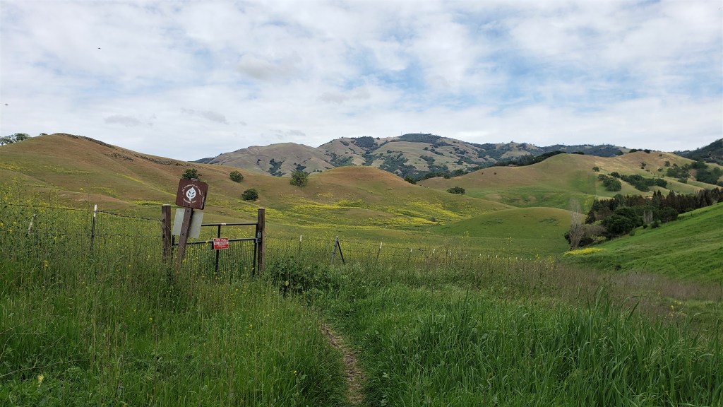
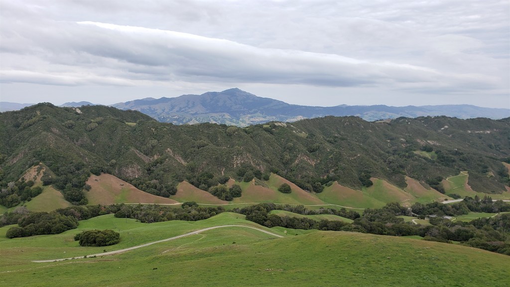
I’ve now done Ordnance four times: in 2015, 2018, 2020, and 2022. It’s a small, low-key race, but one of my favorites. The course begins at the Laguna Seca racetrack just east of Monterey, and makes its way around Fort Ord National Monument. It’s surprisingly diverse: you get sand dunes, oak forests, hillsides covered with chaparral, and open foothills with expansive views. This year’s course was different from previous ones: due to permitting issues, the RD eliminated a long stretch of bike path and rerouted the course along a ridgeline. This added 1.5 miles and 1500′ of elevation gain, for 62.5 miles and 8,800′. Not what you’d call a lot of vert, but enough to keep things interesting. If you look closely at the elevation chart, you’ll notice that miles 21 to 40 look exactly the same as miles 43 to 62. That’s because the lower, southeastern loop is repeated twice.


The race started in the dark at 6:00am. I started slowly, as usual, and ran a few miles in my own little world before seeing the sun rise.

About three miles in, I caught up with Mark Tanaka, a regular at this race. I’d met Mark during this same race seven years earlier: it was my first 100K, and he coached me through it for fifty miles. This year we ran fewer miles together, but I enjoyed chatting with him about optimal pacing, health issues (Mark is an E.R. doctor), and conspiracy theories. However, a race is a race, and around mile seven I wished Mark a good race and picked up the pace.
My favorite part of this course is the oak forest in the first ten or fifteen miles. In the early-morning light, the oaks and lace lichen feel ghostly and magical.

The first 30 miles passed uneventfully: I was running slowly but felt good. Around mile 30, the new course change took effect. Instead of continuing down a fire road to the bike path, we turned right on a single-track that led up into the hills. We then continued along a ridgeline until reaching the long out-and-back down to the Toro Creek aid station. Although the out-and-back was hard–two miles of downhill followed by two miles of uphill–I really liked the course change. The now-omitted bike path was always my least favorite part of the course, and it was a pleasure to run instead along a pretty, rolling ridgeline. I hope Inside Trail sticks with the new course going forward.
Until now I hadn’t thought much about other runners: my cardinal rule is “run your own race.” However, the out-and-back provided an opportunity to assess my standing, since I’d be able to see anyone ahead of me coming up the hill as I went down. At least, I’d see them if they led me by less than 3.5 miles–the length of the out-and-back–and I doubted anyone was that far ahead. However, although I looked carefully for 100K bibs, I didn’t see any. I didn’t know what to make of that. I doubted I was in first, but I didn’t expect Alex Kramer–who I guessed was the strongest runner there–to be already so far ahead.
I saw Megan at mile 40, where she was volunteering at the Laguna Seca aid station. I’d originally hoped she’d pace me for this race, but she sprained her ankle badly in January, so seeing her at the aid station was the next best thing. I asked her what place I was in, and she said third. “Really?” Alex was apparently 40 minutes ahead, which explained why I hadn’t seen him on the out-and-back, but who was second? Megan pointed at someone just leaving the aid station and said he was in second place. That confused me: Why hadn’t I seen him on the out-and-back? Had he skipped it? I’d actually been thinking about this, as the new course was potentially confusing, and some runners I’d thought were close behind me were nowhere to be seen on the out-and-back return. But there wasn’t much point in worrying about it, so I pushed on.
Around mile 45 I glimpsed the second-place runner–Luis Tapia–ahead of me. I gradually gained on him over the next few miles and caught up around mile 48. I could now see his bib clearly–pinned to the back of his hydration pack. “Now I understand!” I shouted. He looked back: “What?” I explained that I’d been looking for 100K runners on the out-and-back but didn’t notice him, presumably because his bib was on his back. Luis said he’d noticed me. We ran together briefly, then I started to pull away. “I’m sure I’ll see you again,” I said. “I don’t know…you’re looking pretty strong,” he replied. He then added, jokingly, “What the hell, man? I’ve been in second for the last 40 miles, and you’re gonna take it away?” I laughed, but yeah, that was the plan.
Once I’d passed Luis, my race changed. Specifically, it got a lot harder. Until then, I’d been running my own race at a leisurely pace. Now, I was determined to put some distance between myself and Luis. There were still 15-ish miles left, and I didn’t relish the thought of running neck-and-neck with someone else the entire way. I figured if I sped up now, I could establish an insurmountable lead and then relax for the final miles. It wasn’t long before Luis was out of sight, but that didn’t mean much, as we were now on a winding single-track where I couldn’t see far behind. The single-track eventually gave way to a wide fire road, where I could see that I’d opened up at least a quarter-mile gap. Still, that’s not much in a long race.
Heading down the out-and-back for the second time, I saw Alex coming up the hill. “Awesome job, man!” I said. “You’re winning by miles!” He smiled and ran on. I was happy for him, but also happy that I’d gained some ground: he was now leading by less than one out-and-back. Still a lot, but I’d closed the gap by pushing the last six or seven miles.
I stopped briefly at the Toro Creek turnaround to drink some ginger ale, then headed out again. As I started up the hill, Luis came charging down. I cheered him on, but I was dismayed to see him so close behind. I’d been pushing the pace for some time, but he had risen to the challenge and wasn’t falling far behind. So much for relaxing the last few miles. I hurried up the hill.

Running up a two-mile hill more than 55 miles into a race is hard. But I still hadn’t left Luis convincingly behind, so I kept at it. I didn’t allow myself to look back, not wanting to look like I was worried. Finally, after cresting the hill and turning down a single-track, I glanced back. I could see Luis in the distance, maybe five minutes behind. Not bad, but not yet time to ease up.
I really like the last five miles of this course: runnable single-track that winds up, down and around rolling green hills. I kept on pushing, no longer worried about being caught, but wanting to finish strong. I saw Megan again at Laguna Seca, only a few hundred yards from the finish. She ran most of that distance with me; I crossed the finish line and was done. When Luis finished seven minutes later, I gave him a fist bump and thanked him for pushing me. I meant it: I owed my strong finish to him. As for Alex, he’d finished 34 minutes ahead of me and had already left.
My time of 10:49 was my slowest ever at this race, but it wasn’t comparable with previous ones due to the course change. My gut feeling was that this was my second-best performance, behind my 9:45 in 2020. But, whatever. I felt I had a good race and was now in better shape for my April-May trials.
As usual, Megan and I spent the night down there, had breakfast in Pacific Grove the next morning, and took a stroll alongside beautiful Monterey Bay before heading home.

Marin Ultra Challenge 50M (March 12)
The Marin Ultra Challenge (MUC) is another standby, being both local and beautiful. The course begins at Rodeo Beach and gives runners an outstanding tour of the Marin Headlands and Mt Tam. Along the way, you see the Golden Gate Bridge, Muir Woods, and miles of California coast. There’s a reason Inside Trail describes MUC as “our premier Marin County long distance trail race.” I didn’t think much about whether to do MUC this year because…of course I was going to do it. Why wouldn’t I?


I didn’t have a lot of goals this year, except to get in another long run before my April-May races. If I clocked a good time, so much the better. I told a friend beforehand that my point estimate was 8:15, with a 90 percent confidence interval of 7:45 to 8:45. That seemed reasonable, as my previous time on this course (in 2018) was 8:10. I’d run 7:42 in 2019, but that year’s course was cut due to flooding, so the time didn’t mean much.
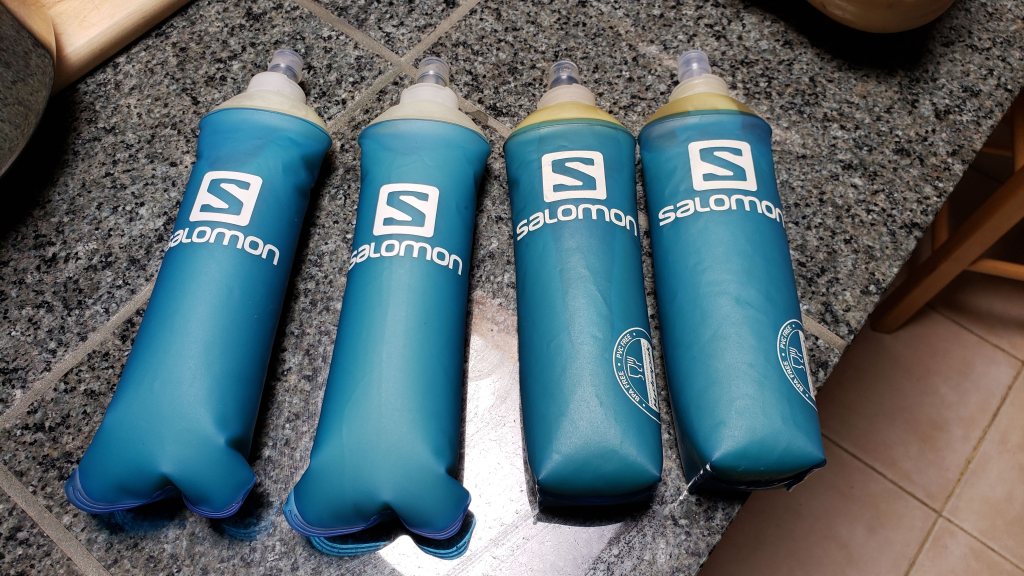
The last time I ran this race, I relied mainly on smoothies for fuel. That often works well, as it’s an easy way to get both calories and fluid. Unfortunately, that day was rainy and cold–not great for chugging down mango juice. So this year I tried something new: potato puree. Boiled potatoes are one of my race staples: they provide complex carbs, are high in potassium, and when salted also provide sodium. The only catch is that I sometimes have trouble eating them during a long race, particularly if it’s hot. By boiling and pureeing them, I hoped to combine the starchiness and saltiness of potatoes with the drinkability of a smoothie. It seemed worth a try. I cooked four large russet potatoes and one Japanese sweet potato, and blended them with salt to roughly the consistency of a running gel. I was able to fit them all into four large flasks:
The race started just after sunrise, at 6:30am. The course begins with a lot of climbing: almost 900′ in the first mile and a half. This consists of a somewhat gradual road followed by some very steep steps. I’m always struck by how many people start their races too fast, and this was on full display at MUC. As I jogged slowly up the hill, I was passed by many people breathing loudly and hard. I’m not generally inclined to give racing advice–everyone has to find their own way–but I think it’s safe to say that you should not be laboring in the first two miles of a 50-mile race. Keeping it easy, I finished the first climb toward the back of the pack and began the two-mile descent back to sea level.
I briefly saw Megan at the Conzelman aid station (mile 6), where she was volunteering. I didn’t stop, but she later mentioned that maybe 50-60 people had gotten there ahead of me. I continued on to the SCA trail, which on a clear day offers great views of the Golden Gate Bridge. Today was not a clear day, at least not yet–nothing but fog, and a lot of wind.
I finally picked up the pace nine miles in, on the long descent down Marincello. While I always take uphills very easy, I like to take advantage of long, runnable downhills, where you can let gravity do the work. In my previous MUCs, I’d clocked at least two sub-6:00 miles per race: one on the long Miwok downhill from miles 2.5 to 3.5, and one on Marincello from miles 9 to 10. This year I’d resolved to show more restraint, as that seemed fast even for a downhill. I coasted down Marincello as effortlessly as I could, but still clocked a 6:10 mile. I guess I can only go so slow on a hill like that.
After passing through Tennessee Valley, I began the roughly three-mile stretch along Coastal to Muir Beach. This is one of the nicest parts of the course–hilly technical trails and great views up and down the coast–but the day was still foggy, so I mostly kept my head down and focused on the trail.
After Muir Beach, Redwood trail takes you to Heather Cutoff, a series of switchbacks that gradually ascends to Coast View. Coast View then continues the climb to Cardiac. I passed many people along this stretch, although I still didn’t have much sense of my overall place. I stopped briefly at Cardiac for some ginger ale, then continued on. I worked on the potato flasks I’d started with, as I planned to replace them on my return to Cardiac in ten miles. I was liking the puree so far: I mean, it’s salted potatoes without the chewing.
From Cardiac, the course follows the Dipsea to Stinson Beach, where a few blocks of road running lead to the dreaded Willow Camp fire road (dreaded because it climbs 1800′ in two miles). The road stretch is maybe the least interesting part of the course, but this year it proved surprisingly troublesome. From Highway 1, runners are supposed to turn right on Belvedere and continue around the bend onto Buena Vista. They are NOT supposed to go up the Matt Davis trail, which has a trailhead on the north side of Belvedere. I was therefore surprised when I found that trailhead marked with two orange ribbons, one on either side. This clearly pointed runners up Matt Davis.
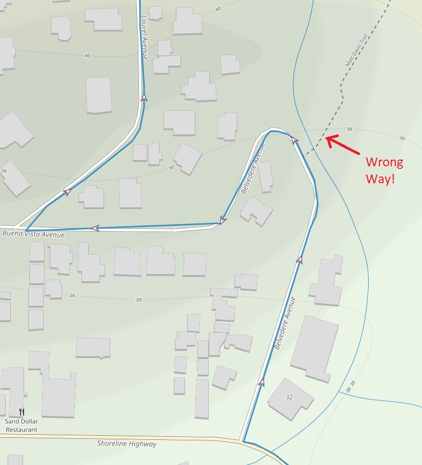
Knowing this was wrong, I scanned the street for other ribbons but saw none. Had there been a last-minute course change? I pulled out my phone and checked the course GPX. It said to take the road, so I did. After turning right onto Laurel, I was relieved to see ribbons again. I really hate wondering if I’m on course.
A minute later, I encountered some race volunteers driving the other way. I told them about the Matt Davis ribbons, but they had apparently already heard, as they were on their way to fix them and place a blue ribbon at the trailhead (blue indicates “wrong way”). I was glad they were on it, but I wondered how many runners had been misled by what I assumed was course sabotage.
I got a preliminary answer a few minutes later, when I reached the Willow Camp aid station. Will Gotthardt, who was working there, asked if I knew what place I was in at Cardiac. I didn’t. He said only two runners had passed by Willow Camp–putting me in third–but those two had been fourth and fifth at Cardiac. The first three runners to reach Cardiac had not been seen. It seemed certain they had followed the ribbons up Matt Davis, which was unfortunate for everyone involved. Willow Camp is the course’s toughest stretch, and taking Matt Davis instead cuts a lot of distance and elevation gain: 1.75 miles and 692′, to be precise. In other words, this was not an innocuous detour, and would one way or another affect the outcome of the race.
This kind of situation has no winners. I felt bummed for the lead runners, who were just following the course markings and would be disappointed when they learned of their mistake. I felt bummed for myself, since now I’d never know if I could have caught any of them. I run more conservatively than most, so I’d been hoping to catch at least some of the leaders later in the race. Maybe I could have, maybe I couldn’t, but now the question was moot. I felt bummed for Tim Stahler, the RD, who would somehow have to deal with this. I wondered–not for the first time–what kind of asshole does this shit for fun. This race wasn’t a big deal to me, but there were many people out here–some running their first 50M–who had trained hard for months just for this. Do the people who sabotage courses think about this? For that matter, what do they think about?
I made my way slowly up Willow Camp, taking care not to push it too hard. About two-thirds of the way up, I heard two women behind me: one who would be the first female finisher and another who would finish fourth. I chatted with them about the course confusion, and they were surprised to learn that I thought it was sabotage. They thought it was just bad marking, but I couldn’t imagine any race volunteers being that incompetent.
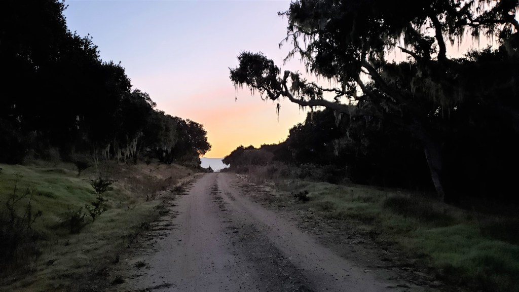
I left them behind after reaching Coastal, which is mostly flat or gently rolling. The skies had cleared by now, and I took my first and only picture of the race:

The trail to Cardiac was an easy cruise. I finished my potatoes along the way. I grabbed my remaining two flasks at Cardiac, but wished (as Megan had predicted) that I’d instead packed a couple of smoothies. The potato puree was great for the morning miles when it was cool and foggy. But now that the sun was out, I craved something more thirst-quenching. Note to self: choice and variety are good things. I use my drop bags sparingly, so it’s silly not to give myself more options.
I enjoyed the next cruisy stretch along TCC: easy running through the redwoods. On the technical descent down Bootjack, I was surprised to hear the first-place female (Samantha Bear) behind me again. I hadn’t seen her since Willow Camp. We ran together for the rest of Bootjack and up Ben Johnson, talking about East Bay running (she lives in El Cerrito), pros and cons of living in the Bay Area, and NIMBYism. At some point, however, I realized her uphill pace was too fast for my comfort, and I wished her a good race. She said I’d probably catch her on the downhill, but I wasn’t sure. Ben Johnson was taking a toll on my legs.
I didn’t see Samantha again until the Deer Park aid station. She was leaving just as I arrived. I gulped some ginger ale and moved on, up Miwok and onto Dias Ridge. I got a big mental lift when I reached the high point of Dias and began the long downhill to Highway 1: a winding stretch with fantastic views toward the coast. I’d also taken a caffeinated Gu, which I reserve for late in the race, and that put some additional wind in my sails.
Approaching Muir Beach, I saw Megan in the “Team Yuch” t-shirt she’d made in 2017 for the Waldo 100K. She’d finished her aid station duties and had run the 10 or so miles to Muir Beach so she could pace me the last 10 miles. (Yes, I realize I’m lucky to have a partner that will do all this.) We headed out, past the Green Gulch Farm and up Middle Green Gulch trail. I felt pretty good at this point and tried to maintain a solid pace up the hill. We were down to the last 10 miles, so it was time–maybe past time–to stop being cautious and run some fast miles. Megan and I talked about the course mishap: she mentioned that the leader, Jonah Backstrom, had reached Muir Beach an hour and 15 minutes ahead of me, and also far ahead of the second-place runner. I figured the Matt Davis shortcut was worth a good 30 minutes, but that still meant Jonah would be leading comfortably even if he’d stayed on course. As for the second and third-place runners, I couldn’t say.
While climbing Middle Green Gulch, I noticed Samantha on the trail ahead of us. We gradually gained on her and finally caught her on Miwok. We were down to the final miles now, and I was trying to run fast, with a lot of encouragement from Megan. We bombed down Miwok to Tennessee Valley, moved quickly up Old Springs, then slowly and laboriously up Wolf Ridge, the last big climb. I breathed a sigh of relief after cresting Wolf Ridge: we were done with climbing and now had two miles of nearly uninterrupted downhill to the finish. This is one more great feature of this race: unless you’ve completely trashed your legs, you can always finish fast. We pushed it down the hill and were done.
After finishing, I mentioned the course sabotage to Tim. He said he was pretty sure he knew who did it. Thinking he meant a volunteer, I said “So it wasn’t sabotage?” He replied that it was most definitely sabotage: he’d marked that stretch of course himself. Apparently there’s a resident of Stinson Beach who doesn’t like runners passing by her house: Tim thought she’d moved the ribbons to send everyone up Matt Davis. Somehow this seemed worse to me than my imagined scenario of teenagers messing up the course for fun. Stupid kids will be stupid kids: it’s unfortunate but comes with the territory. But for an adult to do this just because she doesn’t like a couple hundred runners (this isn’t a big road race!) passing by, once a year, on a public street, when the race organizers have spent good money on a permit–that’s just unbelievably obnoxious and petty. Bay Area NIMBYism at its worst.
In the end, Tim decided to disqualify the three lead runners. That probably wouldn’t have been my choice: I’d have been more inclined to assign a penalty of 30 or 40 minutes. However, these are hard choices, and I respect Tim’s decision. RDs face a lot of pressures, and sometimes get unwarranted flak, because you can’t always please everyone. And it’s true that the race website and pre-race emails cautioned runners to study the course–and download the GPX–because course sabotage is a real thing. In any case, the DQs meant that I finished third. I’d have preferred a worse place in a race that went smoothly, but c’est la vie: I’ll still take the $150 for third place.
On the whole, I was happy with my race. My time of 8:35 was 25 minutes slower than in 2018, but I’m four years older and honestly didn’t push it that hard this year. I was pleased to run negative splits–4:25 for the first half, 4:10 for the second–and to finish strong. I felt good and enjoyed the day. That’s enough.
Yuch’s Birthday Run / Dan’s Farewell Tour (March 27)

Megan recently asked if I could give up races. I suppose the answer has to be yes–ultramarathons are hardly a necessity–but I’m also not sure why I would. Races allow us to see beautiful places on foot, whether it’s the Rockies, the Scottish highlands, the Mt St Helens wilderness, the Swiss Alps, or what. They motivate us to push ourselves. They help build friendships with other runners. So, races have a lot to offer. That said, there are other ways to get these things. The most obvious alternative is the long adventure run: rim-to-rim-to-rim of the Grand Canyon, the Wonderland trail around Mt. Rainier…and the long run Megan, Dan and I did on my 53rd birthday.
This run was conceived as a way to give Dan a last tour of the East Bay before he moves to Switzerland in June. Dan found a 100-mile route already worked out by someone else: we took the first half with minor changes. We settled on the last weekend in March for several reasons. The East Bay is still green at that time, and the wildflowers are at their peak. It’s a month before the Canyons 100K–which Dan, Megan and I are all doing–and so an ideal time for a long training run. For me, that weekend was the midpoint between the MUC 50M (March 12) and the Lake Sonoma 50M (April 9), so it maximized my recovery time. When it landed right on my birthday, I shamelessly named it Yuch’s Birthday Run and trimmed the distance to 53 miles, one for every year.
The route passes through my three favorite East Bay parks: Briones, Mt Diablo, and Las Trampas. Although I’ve done a lot of running in all three, I’ve never tried to connect them. Fortunately, doing so is easy thanks to the Briones-to-Mt Diablo and Las Trampas-to-Mt Diablo regional trails. Those connectors were terra incognita to me, so I was looking forward to checking them out.
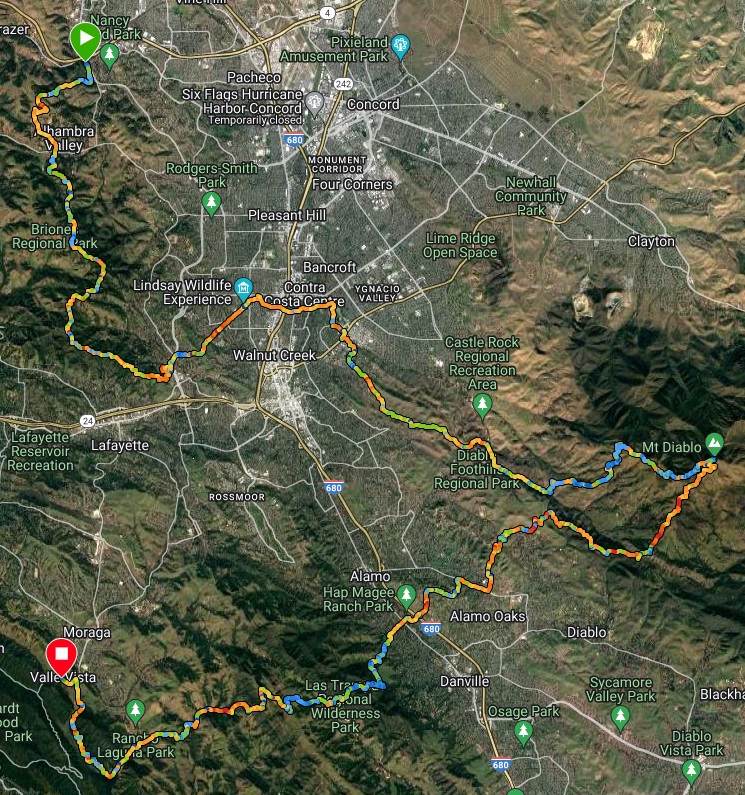

Since this was a point-to-point run, we needed two cars. We met at the finish–the Valle Vista staging area in Moraga–at 6:30am, then took my car to the start: the Mt Wanda trailhead in Martinez. We were off and running by 7:15. Although we expected rain, the forecast said it wouldn’t start until evening, so we hoped to finish before the rain arrived. That morning was cloudy, but it was nice to see the sun peeking under the clouds.


Our first leg took us through Briones, which was hilly and green. The views from Table Top trail were spectacular: Mt Diablo in the distance and wildflowers everywhere. We came across a lone newt. California newts were ubiquitous here only seven or eight years ago, but our ongoing megadrought–the worst in at least 1,200 years–has taken a severe toll. Nice to see a few still hanging on.


We continued along Briones Crest until we reached the Lafayette Ridge Trail, which would take us out of Briones and down to Lafayette. This roller coaster of a trail is one of my favorites: the exaggerated hills look like something from Dr. Seuss.


Lafayette Ridge took us to the start of the Briones-to-Mt Diablo trail. After a few blocks of road running, we turned east onto a dirt single-track. Overall, our route to Diablo involved surprisingly little road running–maybe half a mile in all. We spent a few miles on paved bike path, stopping in Larkey Park to use the bathrooms. Otherwise, we were pleasantly surprised by how much of the connector consisted of dirt trail.


We left the connector trail near Castle Rock regional park, running southeast on Stage Road to Burma Road. (“Road” is a misnomer here: these may once have been fire roads, but they’ve been substantially reclaimed by nature.) Turning onto Burma Road, we began the ascent up Mt Diablo. For those who don’t know Burma Road: this is a steep route up the mountain. The road begins at an altitude of 600′ and ends–with detours on Angel Kerley and Mother’s Trail–three miles later at 2800′. 2200′ in three miles is a lot. As you might expect, this stretch involved some hiking, but also some treats like the mysterious koi pond.


From Burma Road, Deer Flat Road took us to Juniper Campground. This was our first water stop, and we all refilled our packs and flasks. As we headed out, we compared notes on how we felt: tired and stiff all around. It’s amazing how a short rest can cause your muscles to stiffen up, and how hard it can be to get moving again. (Hence the hallowed ultramarathon advice: “Beware the chair.”) But in fairness, we had now covered more than 26 miles and 6000′ of elevation gain, so we could forgive ourselves for feeling fatigued.
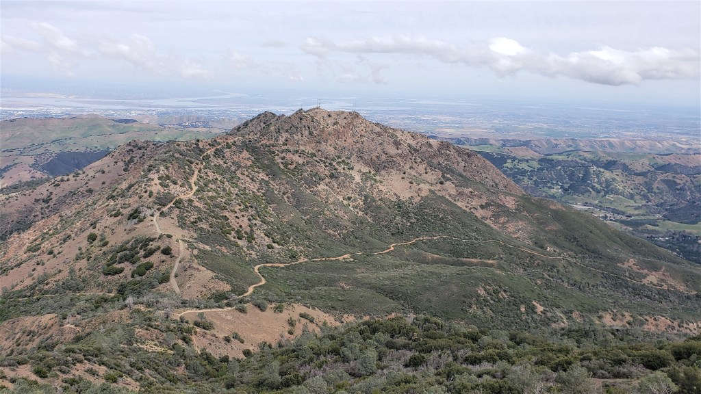
Heading up Juniper Trail, we began the final climb to Diablo’s 3,849′ summit. This went quickly, and we soon reached the summit parking lot. We headed up the observation tower, spent a few minutes eating our sandwiches, then headed back down to the parking lot to refill our flasks again.

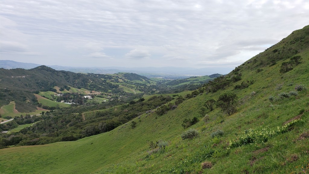
It’s interesting to watch the climate zones change as you move from west to east. The moisture here comes from the coast, and every successive range of hills blocks a bit more water. Despite the drought, Briones and Las Trampas are still lush and green. Diablo is not much further to the east–ten miles as the crow flies–but the grassy hillsides on Diablo’s western flank are already drying from green to gold. East of Diablo, things are drier still: nothing grows on North Peak but shrubby chaparral.
As we left the summit, we were all looking forward to our next leg. Not only were we heading back to (literally) greener pastures, but the next six or seven miles would be varying degrees of downhill: our reward for the brutal climb. We bombed down Summit Trail all the way to Ridge View. I’d never run Ridge View before, but I’d suggested it to limit the route to 53 miles, and it turned out to be a really nice single-track.

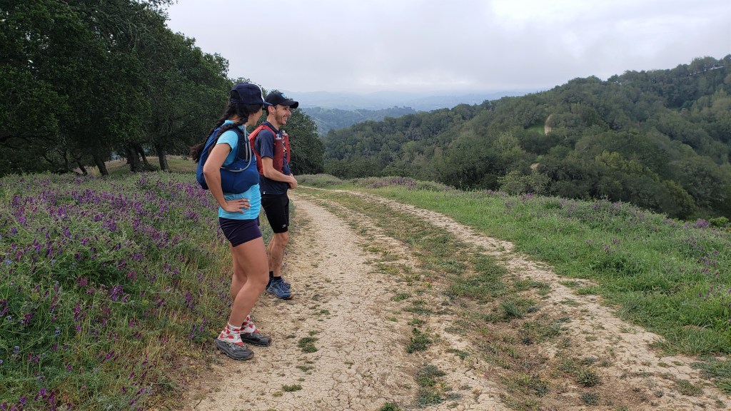
From Ridge View, we turned right and ran along Wall Point Road for several miles: a rolling fire road with great views down to the ridiculously large mansions in Alamo. We spent some time talking about those mansions: who owns them, why anyone would want a house that big, and so on. This was an easy and pretty stretch, with abundant wildflowers of all kinds. Wild mustard was ubiquitous, and we all ate some leaves and enjoyed the horseradish-like jolt. Dan even decided to take some home.


Crossing under Highway 680, we once again marveled at the East Bay trail system. It’s remarkable that, in a metro area with more than eight million people, it’s possible to plot a 50-something mile run that’s almost entirely on dirt trail. Even the stretch through the town of Alamo consisted mostly of leafy dirt trails routed between residential backyards. We hear a lot of well-deserved criticism of state and local governance, but the architects of our regional park system got a lot of things right.
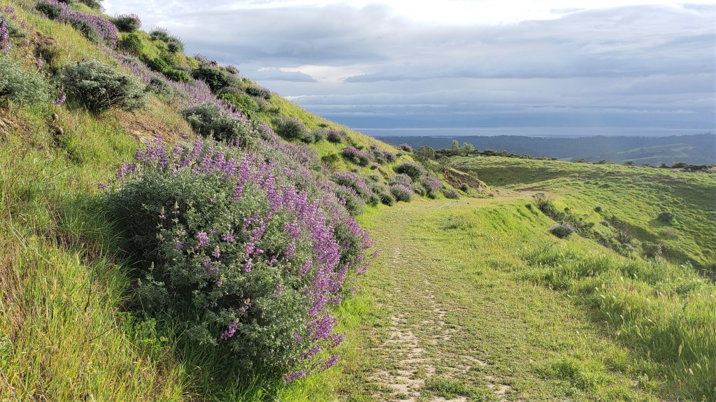
At mile 41, we entered Las Trampas: our final set of big hills. After a mile or so on the Virgil Williams trail, we hit the big climb up Del Amigo. This and Sulphur Springs would take us to Las Trampas Ridge, the first of the park’s two big ridges. This was hard climbing, but the wildflowers lifted our spirits.
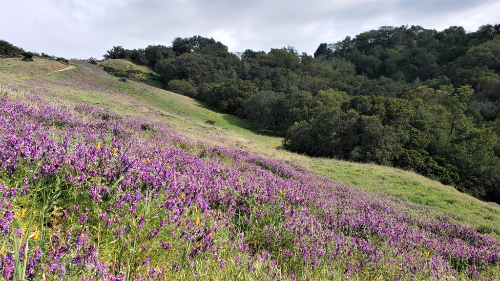
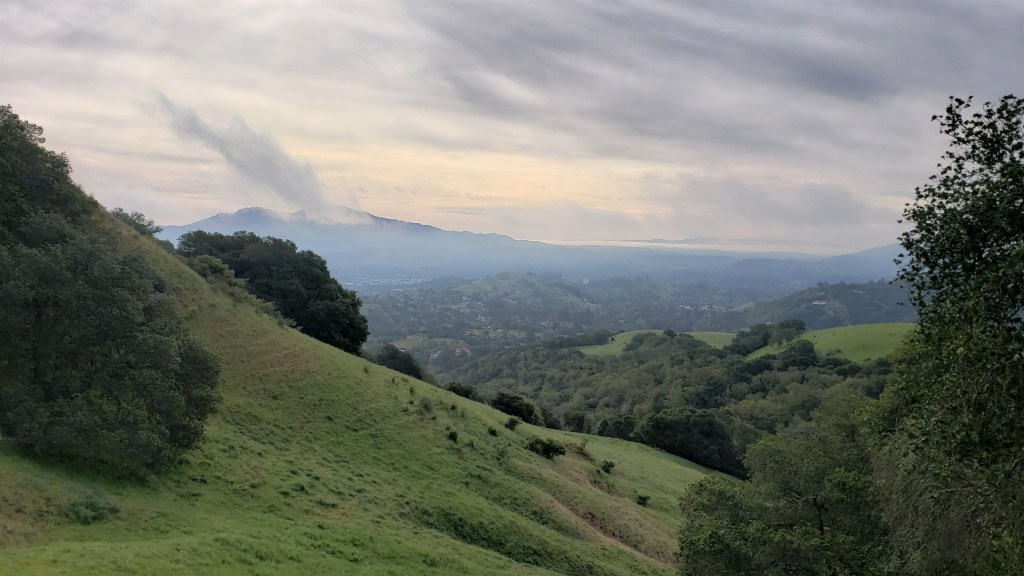
From Las Trampas Ridge, we descended to the Bollinger Canyon staging area, then began the climb to Rocky Ridge: our last big climb! This was also hard, but made easier by knowing we were almost done. The top of Rocky Ridge was cold and windy, but we still took a moment to savor the views. Diablo had receded into the distance, much as it had been that morning, and we discussed how monuments like that lend perspective to these long runs: a sense of where you’re going and where you’ve been.
The wildflower display on Rocky Ridge was sublime, especially when the sun briefly broke through. My phone can never really capture what it’s like to be there, but I gave it my best shot.


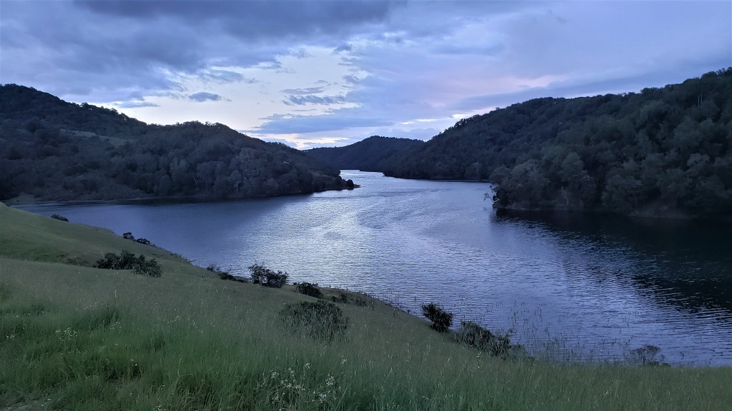
A few more rolling miles took us to the home stretch: the King’s Canyon Loop Trail, which runs alongside the Upper San Leandro reservoir. Dan picked up the pace noticeably here. Megan and I tried to keep him in sight, but I wasn’t inclined to kick it in too hard: I had Lake Sonoma in two weeks and also wanted to take some last pics.

We reached Valle Vista around 7:30–perfect timing, as the sun had just gone down, and the rain had just arrived. We got into the car just in time to avoid getting soaked. I’m not big on birthdays, but I have to say that I really can’t imagine a better one. In the end, according to our watches, we’d run 54 gorgeous miles with 12,500′ of elevation gain. I’ll call that a good day.
On returning to Martinez, we learned that nothing in this world is perfect. While we were out running, someone had broken into my car–for the second time in four months. Each time, someone had smashed a rear window and flipped the back seat forward to examine the contents of the trunk. Each time, the burglars apparently decided I didn’t have anything worth stealing. I actually had a lot of camping gear in the trunk, which makes me wonder what these people are looking for: big bags of cash? In any case, I wasn’t thrilled to find my car window smashed, especially since it was now raining hard. But we’d had a good day, and I wasn’t going to let these morons ruin it. I reminded myself that I could afford the repair, and whoever did this probably had a pathetic life. We met Dan at Los Moles, a Mexican place in El Cerrito, and had a nice post-run meal.
I still see no need to give up races. On reflection, races and adventure runs seem more complements than substitutes: the former help you find your limits, while the latter provide more time to socialize and take pictures. But if I had to give up races, I’d be fine as long as I could keep doing runs like this. So, who’s up for rim-to-rim-to-rim?

Me! Glad you wrote up your b-day run/Dan’s farewell tour. And congrats on your prize purse from MUC (Maybe the thieves were looking for that). You are looking strong for what lies ahead 🙂
LikeLiked by 1 person
Thanks, Meg(an)! 🙂
LikeLike