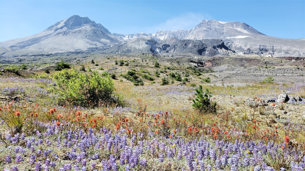
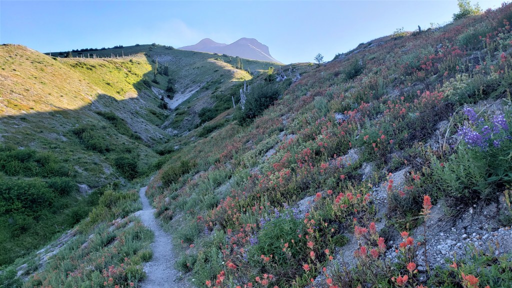
For those who don’t want to read a long race report, I’ll cut to the chase: Bigfoot 73 is the most beautiful race I’ve done. To be clear, many races have beautiful and memorable spots. Most also have a fair amount of “filler”: nondescript stretches where the miles drag on. What makes Bigfoot stand out is that almost every mile is amazing. It’s an almost uninterrupted feast for the eyes. I’ve done other races that have this quality, like the Ben Nevis Ultra. But Bigfoot also stands out for its diversity. It has a little bit of everything: boreal forests, desert landscapes, snow-covered peaks, mountain lakes, spectacular wildflowers, lava fields, and the constant, looming presence of Mount St. Helens. It’s a hard combination to beat.
My decision to do this race was kind of random and last-minute. I’d never heard of it before, although I knew of its better-known cousin, the Bigfoot 200M. I had originally planned to do the Vermont 100 on July 17. However, Vermont was cancelled for a second time due to Covid-19, so I began searching for a replacement. That’s when I found Bigfoot 73. The pictures of the course looked amazing, so I asked Megan if she’d be interested in doing it. When she said yes, that was that.
Although I was excited about the race, I was also a little apprehensive because I’d done the Black Hills 100M two weeks earlier. That race was hard on my legs, and I doubted my ability to recover in time. I did two easy 10-mile runs the week before Bigfoot, and neither was especially reassuring. My left foot was still a little sore–it hurt badly for the last 40 miles of Black Hills–and while it was fine on those recovery runs, small pains can become big in the course of a long race. More importantly, I just felt tired. Ten-mile runs shouldn’t feel hard, at least not with a 73-mile race three days away. I wasn’t worried about my race performance per se: this wasn’t a goal race, and I was fine with being slow. However, I did want to finish the damn thing and ideally see a lot of the course in daylight, since the views were kind of the point. I could only hope three more days of recovery would be enough.
We flew into Portland on Friday, picked up our rental car, and drove up to our Airbnb in Ariel. For us, the logistics were easy: about an hour to fly to Portland and another hour to drive to Ariel. We made ourselves a nice pre-race dinner of roasted vegetables and chickpeas, prepared our drop bags and other race gear, and went to bed.
About that race gear: the race has a long list of mandatory gear that must be carried at all times: jacket with hood, emergency blanket, whistle, long-sleeved insulated layer, full-length pants, hat and gloves, 500 extra calories, headlamp and/or waist lamp. Some of these are no-brainers, but some seemed a little excessive, given the forecast: clear skies, highs in the 80s, and lows in the 50s. I don’t love having such a bulky and heavy pack if I don’t need it, but given the recent ultrarunning tragedy in China, I understand why RDs would be cautious.
Race morning went smoothly, although it took us a little longer than expected to reach the start because we missed a turn. This whole area lacks cell service, and I forgot to download Google maps before coming up here–a rather stupid oversight, since I did download Gaia maps for the course. Still, we reached the start in plenty of time.
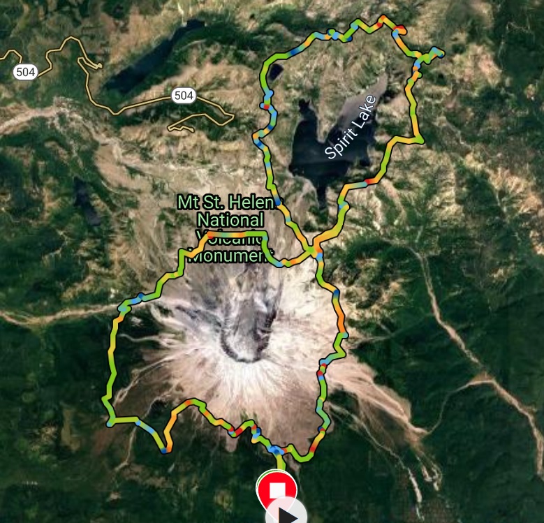
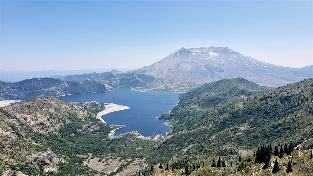
A little info about the race: the 73-mile course is a figure-8 around Mt. St. Helens and the Mount Margaret Backcountry. The lower loop of the figure-8 circumnavigates Mt. St. Helens; the upper loop circles Spirit Lake. It’s this figure-8 structure that makes the race so spectacular, as you get to see Mt. St. Helens and Spirit Lake from every angle and from various elevations.

Going in, we didn’t expect the course profile to be that challenging. The race has 14,410 feet of elevation gain, which is comparable to Canyons 100K and Castle Peak 100K. Since the Bigfoot gain is distributed over 73 miles, this implies a gentler course. What these overall numbers didn’t convey, however, was how technical the course would prove and how slow even some flat stretches could be.
At 5:30am, we were off. It was clear from the start that the last three days hadn’t done much for my legs: they still felt dead. So I started slowly…very slowly. I watched Megan vanish into the distance and wondered if I’d see her again. I suspected not: she was both well-trained and well-rested, and seemed likely to finish well ahead of me. I was fine with that, although I hoped I wouldn’t make her wait too long after the race. It occurred to me that I should have given her the car keys so she could get into the car when she finished.
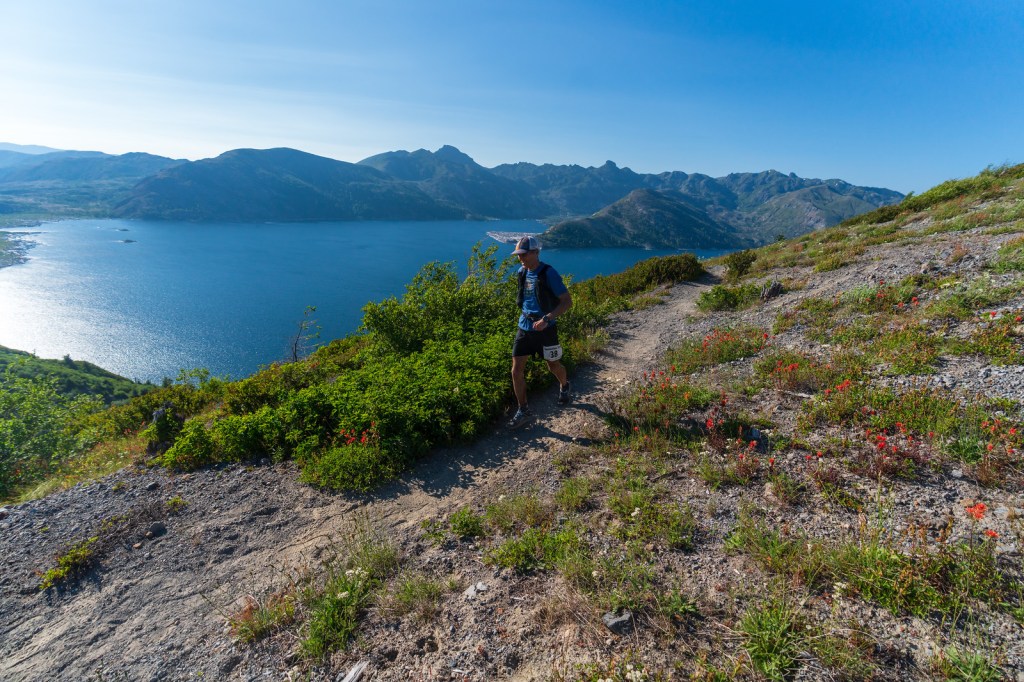
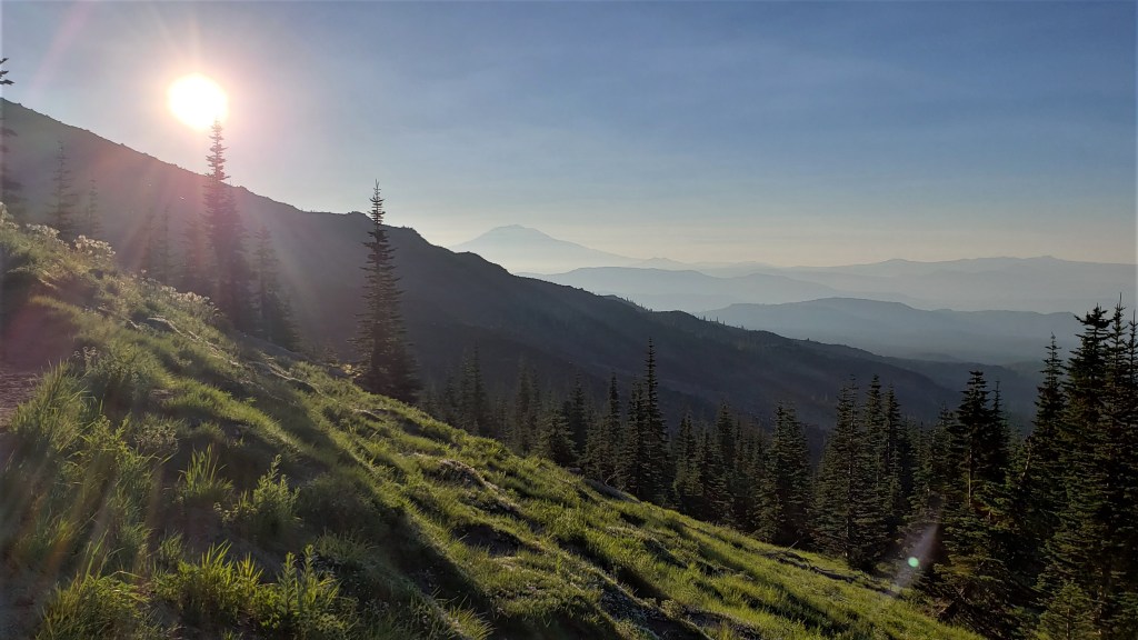
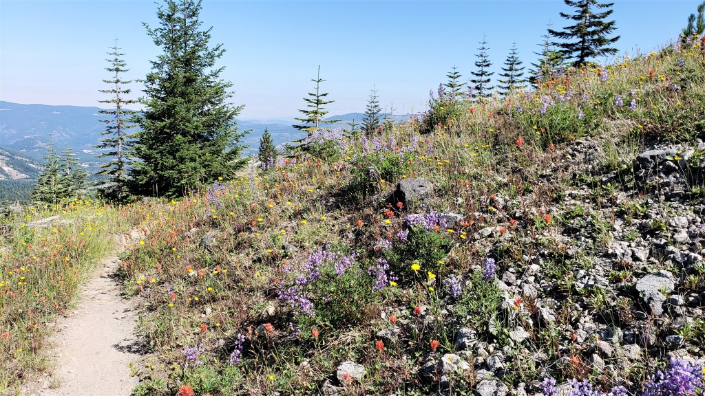
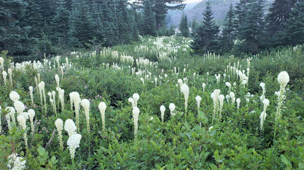
The first two miles were pretty pedestrian: a long gradual ascent through pine forest. After a few miles the course began to open up, and we got our first views. The sun rose above the surrounding mountains, and the trail was flanked by otherworldly white flowers growing on long stalks. Megan later identified them as bear grass. To me, they looked like something out of Dr. Suess.

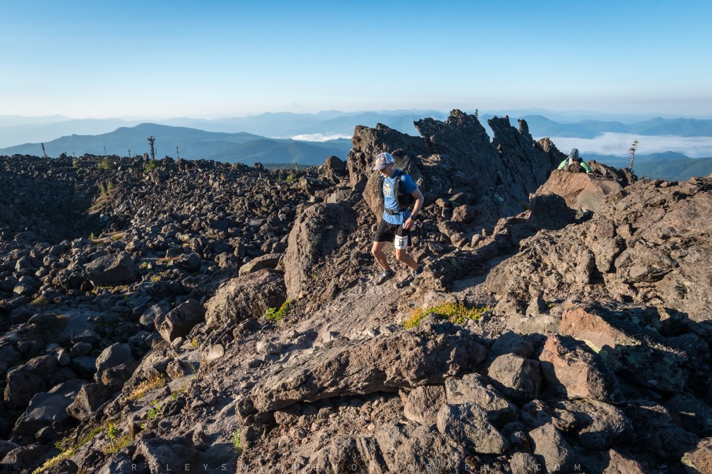
The course continued to climb steadily, with over 2,000′ of gain in the first five miles. We then had a few more runnable miles through pine forest before we encountered our first lava field. This was slow going, as there was no trail to speak of, and we were mostly hopping rock to rock. Fine with me: my tired legs appreciated any opportunity to hike.

Around ten miles in, I took stock of how I felt. Still tired, but able to maintain this slow pace. Left foot sore, but not getting worse. Probably a decent chance of doing the whole race. I should mention that, at this point, that wasn’t the only option. If things got bad, I could drop down to the 40-mile race, which consisted of the southern loop of the figure-8. I didn’t want to go there, as I’d been looking forward to seeing the whole course. But depending on how things went, I might have to consider it. Fortunately, I wouldn’t have to make that decision until the Windy Ridge aid station at mile 30, so I resolved not to think about it until then.
Twelve miles in, I reached the short out-and-back to the first aid station. I was surprised to pass Megan on her way out: I thought she’d be farther ahead. I reached the aid station, topped up my flasks with water, and continued on my way.

I whiled away the next few miles by doing math in my head. I was starting to feel better about my foot–which wasn’t getting worse–but I still felt tired and slow. If neither condition changed, I figured the worst-case scenario was averaging 4mph for the rest of the race. That would get me to the finish in 18.25 hours, i.e., by 11:45pm. That wasn’t my dream scenario: it meant doing many miles in the dark and possibly making Megan wait for hours. But it was better than dropping down to the 40. I began telling myself I could do this if I just kept it easy and slow.
Around mile 15, the soreness in my foot got worse. This worried me: there were almost 60 miles to go, and I didn’t want to run that far on a bad foot. I started thinking again about dropping down but reminded myself I still had 15 miles to make that decision. A lot could change in that time, so I put the matter out of my head and ran on.
A few miles later, we got our first truly spectacular views. The course ascended up one side of a wide volcanic canyon that afforded great views of Mt. St. Helens and allowed us to see maybe half a mile ahead. I looked for Megan on the trail above me, saw someone who looked like her, and waved. The small figure waved back, then continued running. I was glad she was still in sight: if I could hold this gap, I wouldn’t keep her waiting too long at the end.

I passed a guy who’d stopped to take a picture and said “It doesn’t get much better than this, huh?” He agreed. But as I emerged from the canyon, it got better. The dry volcanic dust gave way to green grass and wildflowers, and the trail became gentle and rolling. Running along the canyon rim, I noticed a large cloud of dust below, then heard an unmistakable sound: rockslide! It wasn’t near the course but served as a good reminder to be cautious on the loose volcanic soil.

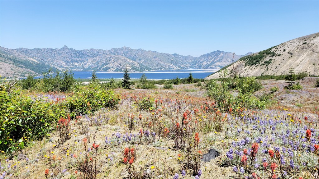
Miles 20-26 (or so) brought a wholly new landscape. We’d seen pine forests, boulder fields and mountain views; now we headed into a flat desert plain with Silver Lake in the distance. Parts of this were very runnable; others were not. There were no big hills to speak of, but the terrain was often rocky enough that running was hard even on level ground. I didn’t mind. I reminded myself to keep it slow and easy and enjoy the race. This was easy to do, as the beautiful surroundings kept my mind in the here and now.


Around this time I began to notice two things. First, my foot had stopped hurting. That was a huge relief, more mental than physical. The soreness had never been bad, but the fear that it would keep getting worse kept gnawing at my mind. I now felt confident that the foot was basically fine. Second, I’d been passing people: maybe a dozen over the last ten miles. I wasn’t speeding up, but they were slowing down. I patted myself on the back for pacing well and reminded myself to keep doing what had worked so far.
Feeling optimistic, I reassessed my goals for the race and began repeating them like a mantra. First, finish all 73 miles. Second, finish them in time to get a good night’s sleep. Third, enjoy the race. I probably repeated these words another five hundred times before the end. They seemed realistic: 4mph would accomplish all three, and I was still well ahead of that pace. I also made a mantra of my race strategy: Easy. Keep it easy. Keep on keepin’ it easy. This was of course Caballo Blanco’s first dictum in Born to Run. I wasn’t thinking about this at the time, but credit where credit is due.
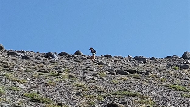
The last two miles before Windy Ridge were on a wide dirt fire road. This wasn’t my favorite stretch, although the views were still impressive enough that I took half a dozen pics. Perhaps a mile from the aid station, I passed the first runner on his way back: a guy in an orange shirt. I didn’t know if he was actually the first runner, or just the first I was in time to see. Nor did I care: if there was one thing I wasn’t worrying about today, it was my place. Still, force of habit led me to count the other runners coming up the road. I passed another three or four before reaching the aid station and saw another three or four there. I figured I was in 8th or 9th or 10th place. I was surprised I hadn’t seen Megan yet, as I assumed she’d be on her way before I reached Windy Ridge.
Coming into the aid station, I saw Megan. It was nice to talk to her for the first time since the start. I said I was in for the whole 73: although I felt tired, I wasn’t having any problems that warranted cutting things short.
Megan had been there a while, as there was a lot to check off before heading out. This race has only four aid stations: Blue Lake (mile 12), Windy Ridge (mile 30), Norway (mile 50), and Windy Ridge again (mile 59). The next stretch to Norway was not only the longest–20 miles–but also the most exposed, and at the hottest time of day. Taking a few extra minutes to prepare was the smart thing to do. I refilled my hydration pack’s bladder and retrieved a few things from my drop bag: two large flasks of mango smoothie, a quart bag of boiled potatoes, a smaller bag of dates, and my Sawyer Mini water filter. I also slathered on a second coat of the SPF 100+ sunscreen I’d left in my bag: excessive, maybe, but this was going to be a hot, sun-baked stretch.
I left Windy five or ten minutes after Megan. I did not feel great as I headed back up the fire road. It was hot and I was tired. I looked forward to getting off this fire road and back onto single-track. This happened two miles later, to my relief. The trail slowly arced around the southern edge of Silver Lake, providing more great wildflower views.
The next five miles were tough. No big ascents or descents, but the terrain was rolling and very exposed. I’m not sure if it was the heat, but it felt hard and slow. At times the trail would disappear into dense vegetation, and only the ribbons placed every few feet at eye level signaled that a trail was even there. (Kudos to the RDs and volunteers for marking this stretch and the rest of the course so well.) My confidence faltered a bit, and I started to wonder how long this would take.
I pulled out my boiled potatoes. After my aid station experience at Black Hills, I decided not to count on aid stations any more. (Ironically, the ones at Bigfoot were excellent.) Megan and I had made a big batch of boiled potatoes the night before and packed them in our drop bags. In the past, I’d used larger potatoes and cut them into chunks, but this time we decided to use tiny red, yellow and purple creamer potatoes. That was a good call. Potato chunks can easily disintegrate, especially when smashed around in packs and drop bags. These small uncut potatoes were sturdier and remained intact. I’d coated mine with olive oil and salt, which was also a good call, although I wished I’d used more salt. It was a welcome change from the sweet stuff I’d been consuming, and I ate the entire bag as I ran along.
At some point the course began to climb, and I once again had great views of the surrounding area. More and more of Silver Lake came into view, as did Mt. St. Helens, and I could see what I thought was Rainier–but was actually Mt. Adams–across the lake.


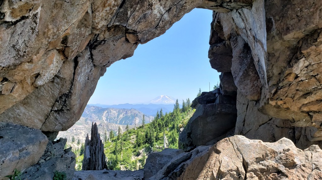
Although I was climbing steadily, I started to feel stronger–better, in fact, than I’d felt all day. It wasn’t so much a second wind as a first. A lot of things came together, I think. I’d passed the halfway point and was glad to be over that hump. I was now committed to doing the whole race and not wasting mental energy wondering if I should. The views gave me a huge lift. I looked up toward the top of the pass and again saw Megan above me. We waved at each other. A little while later I reached the top of the pass, where the trail passed through an eye in the rocky ridge.
The next few miles were amazing. We hear a lot these days about “flow states,” in which we become so absorbed in an activity that we forget all else. I felt like I was flowing. The running was easy; the views were great; and I basically forgot this was even a race. Confident now that I’d hit my goals–finish, and finish in time to sleep–I was able to just relax and enjoy the views. I felt grateful to be out here.
That said, it was pretty hot. Although the temperature wasn’t that high–low 80s–the trail was completely exposed, and the sun was relentless. By now I’d begun to pass the occasional snowfield, so I started scooping up snow and putting it in my hat to cool my head. That felt good. I wished I could get the snow to melt down the back of my neck rather than into my eyes, but I was pretty happy to have it melting anywhere.
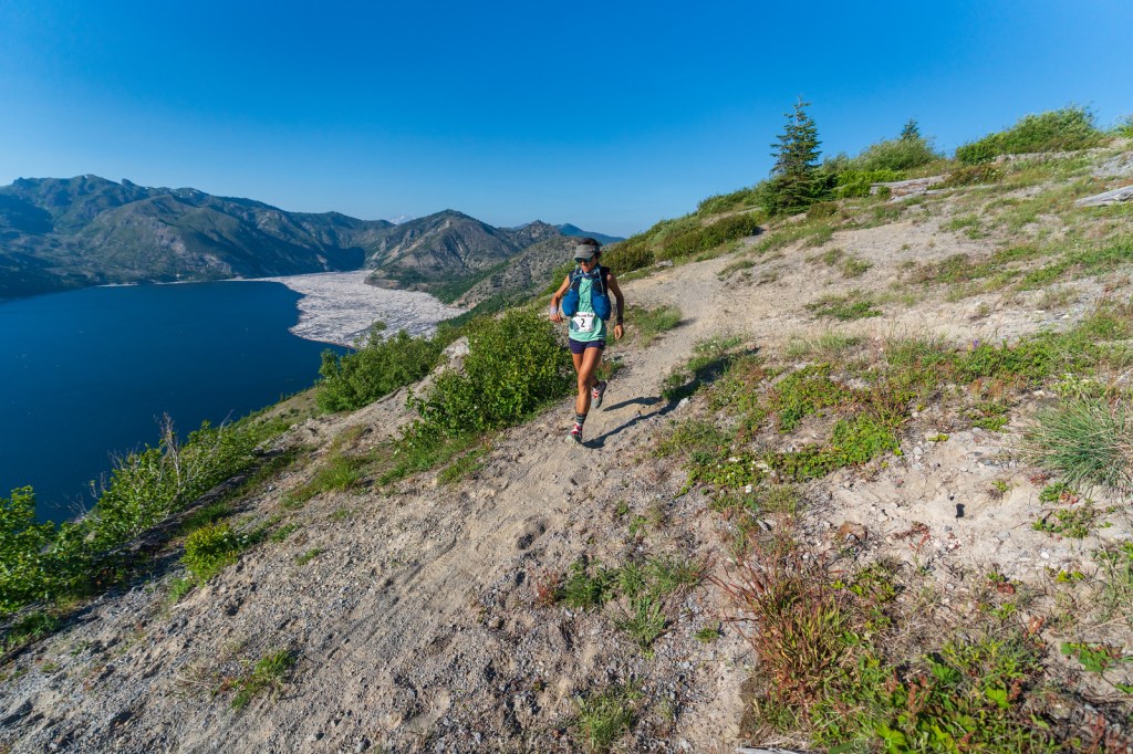
Rounding a bend near mile 40, I suddenly saw Megan by the trail ahead. She’d stopped to filter some water at a snow-fed stream. We greeted each other, and she asked if I wanted to run together for a while. Of course! I filtered some water for myself, and we moved on.
We ran together for the next ten miles, to Norway aid. These were fun miles. We compared notes and agreed that we loved this race. We’d been having similar days: drawing strength from the views, feeling better as the race went on, feeling like this was more an adventure run than a race. We stopped at all the snowfields to put more snow in our hats and shorts.
The last mile before Norway is a steep descent. On our way down, we passed two runners heading up. One was the orange-shirted guy I’d seen leading the pack out of Windy. He looked in bad shape. We encountered no more runners before reaching the aid station. For the first time that day, I started wondering: what place am I in? Thanks to the long out-and-back down to Norway, I knew there weren’t any other runners less than two miles ahead of me. So either someone was even farther ahead than that, or I was in third place. But, whatever. I reminded myself that I had only two goals–finish, and finish in time to sleep–and ran into the aid station.
Norway was a pretty sleepy place: two volunteers and no runners. I grabbed my drop bag and retrieved my two smoothies and another bag of potatoes. I began putting my empty flasks into the drop bag, then remembered what Megan and I had discussed as we ran. We realized that getting our drop bags back after the race might be more trouble than it was worth. The race finish was over 30 minutes from our Airbnb, so we’d have to kill over an hour tomorrow just driving out there to get the bags. That seemed unappealing, so we decided to leave anything disposable in the drop bags (Clif bars, Gatorade packets, sunscreen, GUs, etc.) and to carry with us anything we wanted to keep. A fine plan in principle, but our packs were getting pretty full. In addition to all the mandatory gear, I was now stuffing mine with empty flasks and extra pairs of socks.
I was ready to leave before Megan, but I’d planned to wait so we could continue to run together. However, Norway’s biting flies changed my mind. They were nasty little things, and the longer I stayed there, the more they swarmed around and bit me. I told Megan “I gotta get out of here.” She told me to go ahead; she’d catch up. I figured she would, as she’d been the stronger runner all day.
The climb out of Norway was long and hot. The course occasionally went through overgrown and humid sections, as well as a few steep and technical ravines. I was glad when it once again reached an open hillside with views and a runnable trail. I thought again about my place and again admonished myself not to. Two goals: finish, and finish in time to sleep. But just then, I saw another runner on the trail ahead of me: the orange-shirted guy again. He seemed to be hiking full-time now; I caught up to him quickly and passed. I now knew of only one runner ahead of me, although there could have been more.
After another long descent, the trail spat us out onto a wide paved road. I checked my Gaia map and verified that the next two miles would be paved. I ordinarily hate running on pavement during trail races–or in general, for that matter. However, after all the technical and overgrown stretches I’d just gone through, I welcomed the chance to jog along a paved road. Even one that went relentlessly uphill, as this one did.
Two miles later, I’d had enough of road and was glad to get back on single-track. The trail briefly ascended through dense trees, then opened up shortly before Windy aid at mile 59. The course was now above Silver Lake again, which shimmered in the evening sun. A cool breeze blew off the lake. This was also an uplifting stretch to run.

I spent very little time at Windy 2: just enough to grab my last two smoothies and the used flasks I’d stashed there earlier. My pack was getting really full. I thanked the volunteers and left. I wondered if Megan would catch up to me, but I was starting to doubt it, as I’d been moving well since Norway.
As I left the aid station, I noticed that I was starting to see 40-mile runners: some still heading toward the aid station, others leaving it behind. That made sense: since the 40-mile is a subset of the 73-mile, the first and last 20 of both races are the same. Most of the 40-milers were walking, which also made sense: if you were still at the 30-mile mark more than twelve hours into the race, you probably weren’t running.
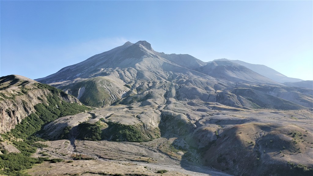
Two miles out of Windy, the course left the fire road and took a single-track up a ridge. This was also a beautiful stretch. Someone had rigged up “steps” in the really steep parts, consisting of two cables and wooden slats. These were helpful–much better than trying to hike the loose volcanic soil. Reaching the top, I found spectacular views of the mountain’s old lava flows and the surrounding plain. It felt exhilarating, and I exclaimed “This is so awesome!” aloud.

The next few miles were a blast. The trail was rolling for a while, and flanked by more beautiful wildflowers. I passed a few 40-milers. With only tennish miles to go, this felt like the home stretch, and I was tempted to push it a bit. But, I reminded myself I’d gotten this far by taking it easy, and that’s what I mostly continued to do. The rolling trail gave way to an extended flat stretch, where I managed an 8:30 mile–my fastest that day. Looking at my watch, I began to think I could break sixteen hours. All I had to do was average 12-minute miles for the rest of the race, and that seemed realistic right now.


The fast miles didn’t last. The trail become rockier and took us across several steep volcanic ravines. There was nothing tricky about these, but I was surprised at how close the trail often ran to the crumbly looking edge. A fall here wouldn’t kill you, but it could definitely mess you up. I hiked down one side and up the other, thinking that maybe I wouldn’t break 16:00 after all.


Soon after the ravines, the trail became more runnable and also more green. The bear grass here was spectacular, covering the hillsides as far as the eye could see. I was making good time now and again toyed with the idea of breaking 16:00.

I soon abandoned those thoughts once and for all. The course led to another boulder field. I’m not sure if it was harder than the first one, but it sure felt like it. My balance was not what it had been, and I felt strangely incompetent hopping from misshapen rock to rock. The course ribbons were hard to follow here, so I relied on my GPX to stay on course. At least I wasn’t the only one moving slowly: I passed many 40-milers here. One asked if I’d heard the bear. “Bear?” I asked, just as we heard a roar from the woods below. “That bear,” she said.
At least I’d be through this boulder field before dark. I thought of all the runners who’d be doing it in the dark and wondered if Megan would be one of them. I had no idea how far behind me she was: five, ten, twenty minutes? For her sake, I hoped not far. Navigating these boulders in the dark wouldn’t be fun.
I was relieved to finish the boulder field and return to the trail. Things didn’t get much faster, however, as the trail remained so rocky that running was mostly out of the question. I picked my way down and finally left the rocks for the woods.
When I entered the woods, my world suddenly got very dark. I turned on my LightBelt and kept running, past the 40-milers who now seemed to be everywhere. I was now in the home stretch: just a few miles of runnable downhill through the woods. There were no real challenges here, except that I had a hard time seeing the course markers. The ribbons were hung at eye level, above my light belt beam. There weren’t many wrong turns to take, but I consulted my GPX frequently just in case. At one point, maybe a mile from the finish, my Gaia map told me I’d gone off course. According to the GPX, I’d missed a turn maybe a quarter-mile back. I ran back up the hill to the alleged intersection and found…nothing. The trail I was “supposed” to take didn’t even exist, so I ran back down the way I’d come and eventually found some course markers. This was my only navigation failure of the day, and while it hadn’t cost me much time–maybe seven or eight minutes–I felt annoyed to have gotten confused on the most straightforward part of the course.
Five minutes later, I was done. I hadn’t broken sixteen hours, but I wasn’t too far off, at 16:25. I finished in third place overall: not bad, considering I’d spent the first 25 miles wondering if I could even finish. All I really cared about, though, was that I’d run all 73 miles and seen most of them in daylight: that was more than enough. I thanked the finish line volunteers for an amazing race. Thirty minutes later, Megan finished in 16:55, the first-place female by nearly two hours.
I took a few things away from this race. First, localized pains sometimes go away. I’d spent a lot of early miles obsessing about my sore foot, mostly because I assume these things just get worse. This kind of catastrophizing is not helpful, so it’s good to know they sometimes get better. Second, the Nth wind is a real thing. I’ve heard a lot about ultrarunners getting their second or third wind, but I mostly haven’t experienced this: for me, fatigue usually leads to worse fatigue. I’d never imagined I could feel so much better at sixty miles than at ten, but now that experience will stick with me. Third, you can only infer so much from an elevation profile. Megan and I both assumed the last miles would be fast, as they were mostly flat or downhill. But some of the flattest parts–the boulder fields–were also the slowest. Finally, sometimes you run your best race when you stop caring about the race. What got me through this race was enjoying the experience, and it’s hard to see how pressuring myself could have been anything but counterproductive. It’s true that, in this case, my tired legs and low expectations helped me to approach this race as a fun run. But it’s probably worth striving for the same mindset even when one has competitive aspirations. Because, in these long races, the biggest competitive boost may come from having a good time.
I realize there’s a lot of redundancy in this post. I’ve used the same adjectives–beautiful, amazing, spectacular–many times. Maybe I need a thesaurus, but this was also how I felt about the course. I don’t know if I’ll do this race again, but I’ll definitely recommend it to anyone looking for a great mountain ultra. In fact, Megan and I could think of only one thing that would make it better, and maybe put it on the ultrarunning map: someone needs to put on a Bigfoot suit and occasionally appear to runners along the course. Not too close, not to all the runners, and maybe not even in every race. Just often enough to get the rumors going and keep them alive.

So glad you got to experience the Nth wind & the performance benefits of having a good time!
LikeLiked by 1 person