
Last year I wrote a long report on Desolate Peaks, with lots of pictures, course descriptions, subjective impressions, etc. Here’s a link if you want all of that. This year I’m just going to focus on what was different and how that affected my race. Here’s what changed:
1. This year was way less windy. Last year we had howling winds all day and night, which made the day cooler but the night horrendous. This year was calm, which made the night WAY easier. Those last six peaks were a lot of work, but not stressful like last year.
2. Start to Mt Price: 8 minutes slower
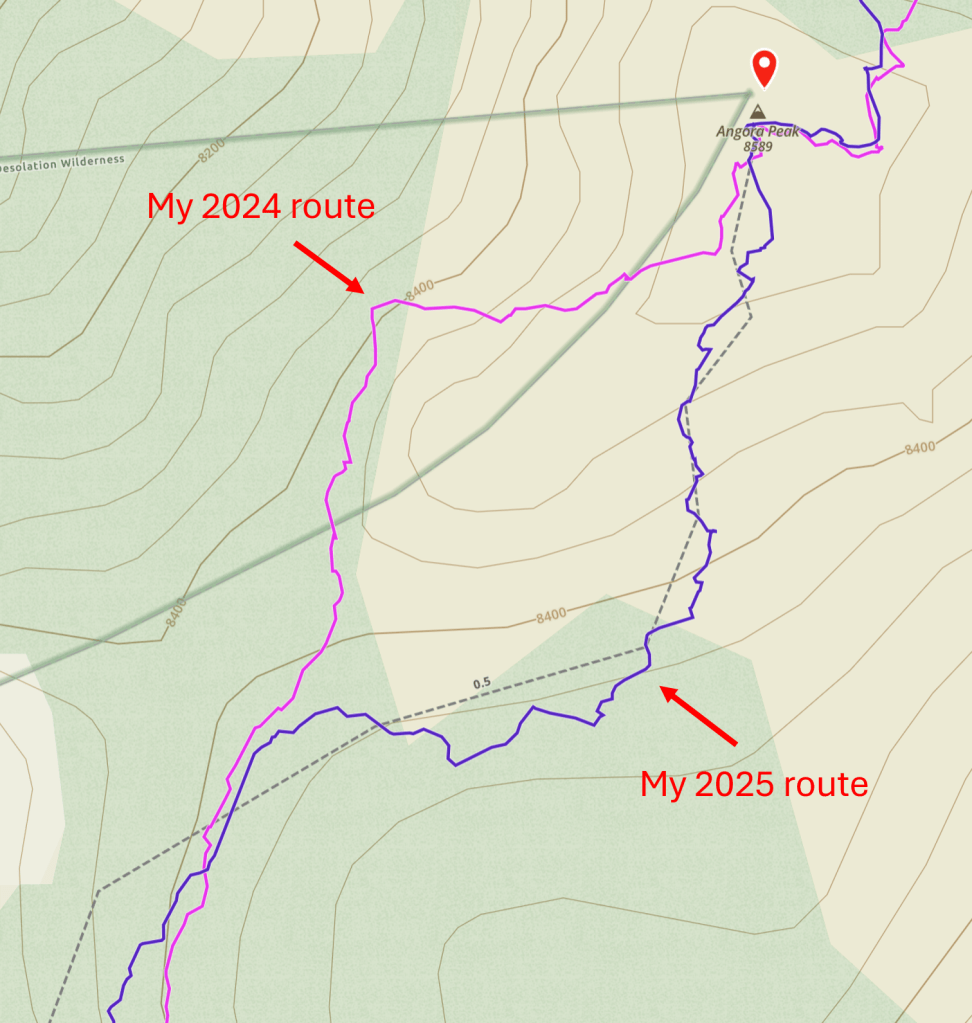
AJ Kaufmann was kind enough to share his 2024 track, which diverged from mine early on, in the approach to Mt Price:

My 2024 route wasn’t really my choice: it’s just where everyone ahead of me went, and I mindlessly followed. This year Shane and I went that way again, on the grounds that it worked last time. As we learned, however, it worked last time because we had others to follow: this year, without such guidance, we wasted a lot of time finding the route and picking through rocks. Once we’d ascended a bit, I could see that AJ’s route made more sense: it stayed on a trail for longer, then climbed some easily traversable slabs before hitting talus. Our route choice here slowed us by 8 minutes relative to last year, and probably by more relative to this year’s other runners–who wisely chose to follow AJ’s route. If I do this again, I’ll do the same.
3. Mt Price to Pyramid Peak: 12 minutes faster

I didn’t do anything special in this section except avoid the impassible ledge I got stuck on last year, just north of Pyramid Peak. This mostly explains the 12-minute improvement, getting me to Pyramid just ahead of last year’s time.
4. Pyramid Peak to Cracked Crag: 9 minutes slower

For some reason my descent from Pyramid was less efficient this year. It was less direct; it descended further, requiring me to climb again; and it stayed on talus longer rather than exploiting the more runnable slabs. I knew I’d gone wrong when I returned to the better route and saw some people who had been behind me now ahead. This poor route choice mostly offset my gains enroute to Pyramid, and I arrived at Cracked Crag five minutes slower than last year.
5. Cracked Crag to Keith’s Dome: 20 minutes faster

Last year I went off-trail from Cracked Crag to Margery Trail because this allowed me to stay up high. This year I chose to descend back down to the PCT because that off-trail route proved really slow. This was the right choice and shortened the trip by 20 minutes. Not all of that improvement reflects the route: last year I stopped for water at Lake Lucille, which probably took five minutes. But still, the PCT is the way to go. It involves more vert but gives you much more time on runnable trail rather than talus and sand.
6. Keith’s Dome to Echo Lake: 15 minutes faster
There’s no real route-finding on this section, so I mostly just moved a bit faster, both from Keith’s Dome to Ralston (4 minutes) and from Ralston to Echo (11 minutes). I think I had a better sense this year for when it’s easier to move along the top of the Ralston-to-Echo ridge and when it’s better to drop down to the side.
7. Start to Echo Lake: 30 minutes faster
I got to Echo Lake in 8:50 this year, a half-hour faster than last year’s 9:20. While I was happy about this, I think I could shave off more time by taking AJ’s route to Mt Price and crossing Desolation Valley more efficiently. So, that’s on the agenda if I do this again.
8. Echo Lake to Angora Peak: 16 minutes faster
My improvement on this stretch was almost entirely between Echo and Angora Peaks. Compared to last year, there were two main changes. First, I took less time crossing the sketchy gap in the ridge (I’ll assume everyone who’s done this knows what I mean). Last year I spent a while studying the gap and eventually decided to climb down and then back up the ridge’s west side: this approach is technically more difficult but also less risky, as the fall on the west side is less dangerous. This year I followed Zoe’s lead and climbed directly across. This is really not that hard, but you do want to be very careful, as a fall here would be really bad. It’s worth noting that one of my handholds–a large rock flake–moved in an unsettling way when I grabbed it, so make sure everything you’re grabbing or stepping on is solid before giving it any weight. In any case, this more direct route was faster, so thanks to Zoe for showing me the way.
Second, this year I correctly approached Angora by going east of the false summit rather than west:
Last year I tried the western approach because it involved less descending, but I quickly discovered that it’s a steep, slidey mess. The eastern route is comparatively straightforward and got us to Angora pretty quickly. Matisse was taking a break there, and led the way down to Fallen Leaf.
9. Start to Fallen Leaf: 52 minutes faster
I reached Fallen Leaf in 11:38, 52 minutes ahead of last year’s 12:30.
10. Fallen Leaf to Cathedral Peak: 38 minutes faster

This year I took the steep ravine to Cathedral Peak rather than the gradual Cathedral Trail. The journey was 38 minutes faster, but this can’t be attributed wholly to the new route. Last year I left the Fallen Leaf aid station three times, returning twice for things I’d forgotten. This year I somehow managed to leave just once, which probably saved me 10 minutes. Last year I also stopped at Cathedral Lake for water (maybe 5 minutes) and reached the Cathedral plateau in the dark, meandering wastefully enroute to the peak (see above track). All of these things probably added ~20 minutes to my 2024 time. Even so, I’d say the steeper and more direct route is a good 20 minutes faster than Cathedral Trail.
The reason it’s not even faster, despite being so much shorter, is that the ravine is really steep. It rises 1,972 feet in 0.52 horizontal miles, for an average grade of 72 percent. (The traveled distance is 0.64 miles, but that’s the right triangle’s hypotenuse, not its base.) And the actual grade is rarely the average grade because the ravine consists of many steps and ledges: you climb up a step, walk forward on a ledge, and repeat over and over again. It’s clearly been carved by water, so I’m guessing this is a series of waterfalls in the spring. In any case, it’s a really long and hard climb, and I was exhausted by the time I reached the top. That said, it’s not scary: the hand and footholds are consistently good, and the step structure means you’re never risking a really long fall. So if you’re looking to do this race quickly, this is the way to go.
11. Cathedral Peak to No Name 9579: 8 minutes faster

The net 8-minute improvement on this section reflects a couple of things that went well and one that didn’t. My ascent to Tallac was 5 minutes faster, mostly because I followed AJ’s lead and took a direct route to the summit rather than the more circuitous Floating Island Trail. My descent from the summit was slower, however, because I tried and failed to follow AJ’s off-trail shortcut down. This section is all talus, so I couldn’t look at my phone, and I got off course in the dark. Even after I left the talus, I blundered around for a bit, confused by what my phone was showing me. Fortunately Liz came down the trail just then and got me back on course. I probably wouldn’t attempt that shortcut again, even during the day, as it doesn’t save that much distance and the talus is slow.
Liz helped me make up for lost time by leading the way across the ridge to the next peak. I find this ridge impossible to navigate in the dark, and I get off course the moment I stop looking at my phone. Liz seemed to know her way around, so I had the luxury of just following her much of the time. By the time our paths diverged–she was doing 21 peaks–we were at the No Name just above Dick’s Pass.
12. No Name 9579 to Dick’s Peak: 4 minutes faster
I’m surprised that my improvement here was so small, given how much more smoothly it went than last year. Maybe it’s because I stopped at Dick’s Pass to put on a bunch of layers? Regardless, this section felt very different for a simple reason: I took the correct route to the summit. Last year Dick’s scared the crap out of me due to a steep technical climb in the cold, windy night. This year I approached the mountain with dread, waiting for that climb to appear. And waiting. And waiting. But it never came. I followed what appeared to be the obvious route, and it was consistently easy and safe. So, last year I somehow wandered off course into a needlessly technical climb. I’m not sure how this happened, but I’m guessing I was just less attentive in the wind, which had been eating my brain. I’m also not sure where it happened, but there is one point where my 2024 and 2025 tracks diverge, between 9,400 and 9,600 feet:

Anyway, there’s not much of a lesson here except that Dick’s is pretty easy if you stay on the proper route. Which apparently everyone but me can do.
13. Dick’s Peak to Jack’s Peak: 9 minutes slower
Not sure why I slowed down here, except that I stopped twice to remove stuff from my shoes. I did find the descent from Dick’s hard to navigate in the dark, but I assume that was also true last year? Last year I was desperate to get off the windy summits, so maybe that led to a faster descent? Who knows.
14. Jack’s Peak to No Name 9441: 20 minutes slower
This part, along with the climb to Cathedral, differed most from last year. Last year I took a direct route from Jack’s to the final peak, descending to the Rubicon Trail and climbing up the other side. I guess I should say I “tried to” take a direct route, since I got lost on the descent and blocked repeatedly by brush and rocks on the climb. This year I hoped to avoid those problems by following AJ’s route down to Mosquito Pass, then up to and along the ridge. While this route is longer, it potentially cuts the vert because you don’t have to descend all the way to the Rubicon. Based on my limited knowledge of that ridge, I thought it might also bypass the brush and other obstacles of the previous year.
I’ll say four things about this year’s route. First, it was 1.1 miles longer than last year’s–although, if I hadn’t gotten lost last year, the difference would probably be more like 1.4. Second, my Garmin data for that stretch doesn’t indicate much difference in elevation gain. That may seem surprising, given that the ridge avoids a significant descent, but the ridge itself has quite a bit of rolling enroute to the peak. Third, I suspect that the ridge is slower than a more direct route. Last year’s journey was not fast: I wasted a lot of time getting lost; I chose a poor route to the peak and was constantly stopping to figure things out; I was exhausted and moving at a snail’s pace. In contrast, I did not get lost or stuck this year and was feeling and moving well. But in spite of all that, the ridge took 20 minutes longer. This makes me think that a well-planned direct route from Jack’s to 9441 would save a lot of time.
Fourth, however, I kind of liked the ridge. It was what I expected: a ton of bare granite slabs free of talus or brush. There were difficult sections, but for much of the ridge you could move easily and quickly–and this was a welcome change. So while I’m not sure I’d take this route again, it had its charms.
That said, it was pretty hard. Like most other parts of the course–the endless talus of the Ralston-to-Echo ridge, the ravine to Cathedral, the descent from Jack’s–it just went on way too long. The moon was only a crescent, but at some point there was enough moonlight to make out the final peak–and the two climbs before it. Knowing you’d have to climb those rocks, descend down the other side, and climb again was demoralizing. I suppose the lesson is that there’s no easy route.
15. No Name 9441 to Finish: 4 minutes slower

I descended from 9441 differently this year, following AJ’s route to Island Lake rather than taking last year’s more gradual descent. I honestly have no thoughts on this change. I was four minutes slower this year, but I have no reason to think that’s due to the route as opposed to just moving more slowly, stopping to replace my light’s battery, etc. To be honest, both routes kind of sucked. But maybe everything sucks by this point in the race. The last couple miles of flat trail felt as hard as anything I’d done to that point. So we’re back to “there’s no easy route”.
16. Start to Finish: 70 minutes faster
My watch clocked 24:19 last year and 23:09 this year, so I’ll say I was 70 minutes faster. I’m using equivocal language because my official 2024 time was 24:46, and I can’t explain this difference. But everything in this post has been based on my watch data, so I’ll stick with that. Either way, my time was over an hour faster, so I’m happy about that. But I also feel like I left a lot of room for improvement. If I had to do it again, this would be my list of do’s and don’ts:
Do: take AJ’s route to Mt Price, a more efficient route across Desolation valley, the PCT from Cracked Crag to Keith’s Dome, the eastern approach to Angora, the ravine to Cathedral Peak, the most direct trail to Tallac, and the correct route up Dick’s.
Don’t: take AJ’s shortcut down from Tallac, or the ridge to the last peak–find a more direct route.
That’s what I learned this year!
Since this has been a fairly “clinical” report, I’ll close by saying that this is a really special event. I’ve yet to do another race that is physically and technically challenging in so many different ways while also being absolutely gorgeous. Part of me wishes the race could “go public” so more people could experience it: I suspect it would draw adventure-seekers from far and wide. But Desolation is a wilderness, and there’s much to be said for quirky, low-key events that attract a small but dedicated community of freaks. So maybe it’s just as well this remains “NOT AN OFFICIAL EVENT”.
